Explore Downtown Richmond's Parks
Visit any of Downtown Richmond's riverfront parks in our city's expansive and assorted park system
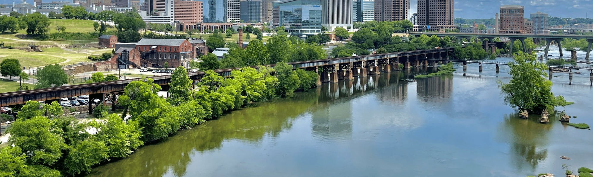
The James River Park System, a unique part of Richmond’s Department of Parks, Recreation and Community Facilities, includes more than 550 acres of shoreline and islands in Virginia's capital and features the centerpiece of our city and liquid lifeline of Richmond: the James River. The James River Park System (JRPS) encompasses a majority of the fall line of the James River in downtown Richmond. Rocks, rapids, meadows and forests make for an abundance of unspoiled natural beauty mixed with a little bit of wilderness to make downtown Richmond an urban jungle ready to explore.
Parks in Richmond, VA
Downtown Richmond's parks are easily accessible and a go-to pick for Richmond visitors and residents
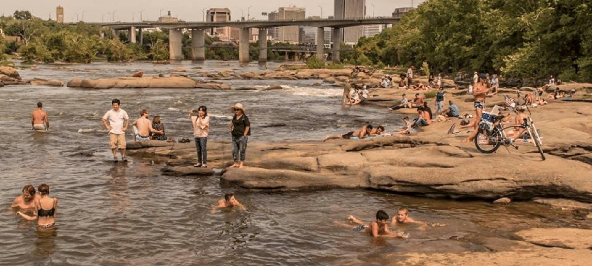
Located along the James River in downtown Richmond, Belle Isle is a great place for people with a love for the outdoors, granting them the opportunity to view wildlife in its natural habitat. From wooded areas to mountain biking trails, interpreted historical sites, a granite wall for rock climbing and wheelchair-accessible fishing at the quarry pond, visitors have a variety of options to choose from.
Brown's Island is managed and maintained by Venture Richmond and offers six acres of riverfront with access to the James River, surrounding James River parks, outdoor concerts and more for visitors, residents and employees of Downtown Richmond.
You can also rent Brown's Island for various events, such as marathons, festivals, and more!
Below the fall line, just east of downtown Richmond, you’ll find some of the lesser known and quieter parts of the James River Park System, like Great Shiplock Park. The lock found at Great Shiplock Park connected the James River with the Richmond Dock, completing the James River and Kanawha Canal system that bypassed seven miles of falls and continued 197 miles through Virginia’s western mountain ranges. The canal served as a transport hub for the tobacco warehouses along downtown Richmond’s Dock Street. Great Shiplock Park marks the lowest lock in a system of locks that once connected the James River with the Richmond Docks. In late March through early June, the fishery in this area is influenced by anadromous fish, which are migrating from salt water to fresh water on their annual spawning runs. Great Shiplock Park also serves as a gateway to the Virginia Capital Trail and Low Line Gardens.
Chapel Island was named after an Episcopal chapel that was located there and active prior to the 1741 founding of St. John’s Episcopal Church in Church Hill. For access to Chapel Island, take the footbridge across the canal from Great Shiplock Park. Chapel Island offers different types of fish such as shad, white perch, rockfish, smallmouth bass, herring and several types of catfish. There is also a half-mile of winding, wide and flat single-track for hikers and bikers. Additionally, the central gravel path continues west along the island through the retention basin owned by the DPU to the 14th Street boat take-out.
Ancarrow’s Landing and Historic Manchester Slave Docks
Ancarrow’s Landing, the easternmost section of the park system, has recently undergone a major renovation, including an expanded and improved parking lot, new lighting and extended and enhanced trails. This park section is a prime spot for the running of the shad every spring. The trail loop is accessible from the east side of Ancarrow’s Landing and offers family-friendly riding for beginning mountain bikers. Ancarrow’s Landing is also the beginning of the Richmond Slave Trail. Seventeen markers along the Slave Trail display somber and illuminating information on the history of slavery in Richmond. The trail goes from the Manchester Docks at Ancarrow’s, across the river into Shockoe Bottom to Lumpkin’s Slave Jail. This self-guided trail covers nearly three miles.
James River Park's Outdoor Amenities in Downtown Richmond
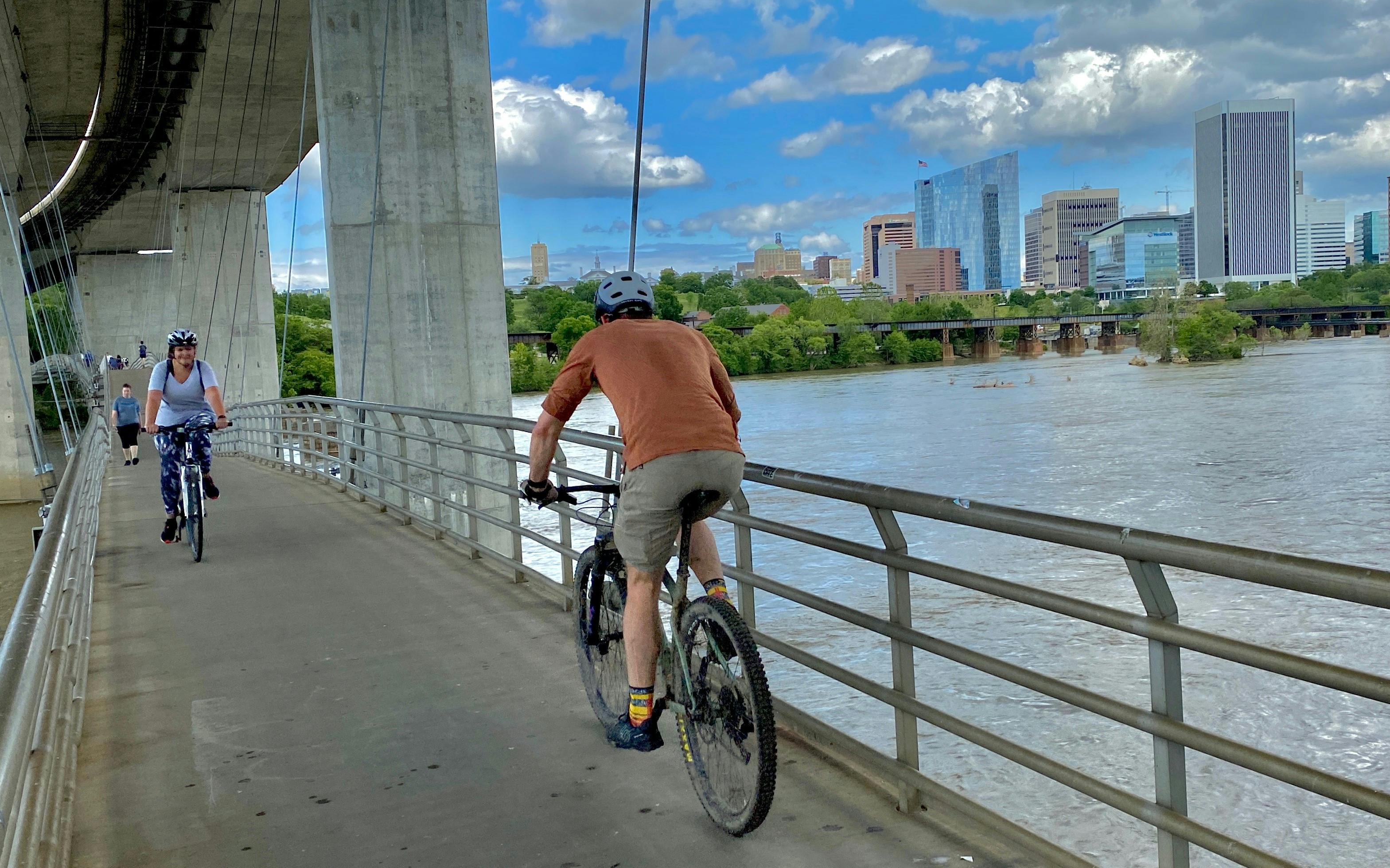
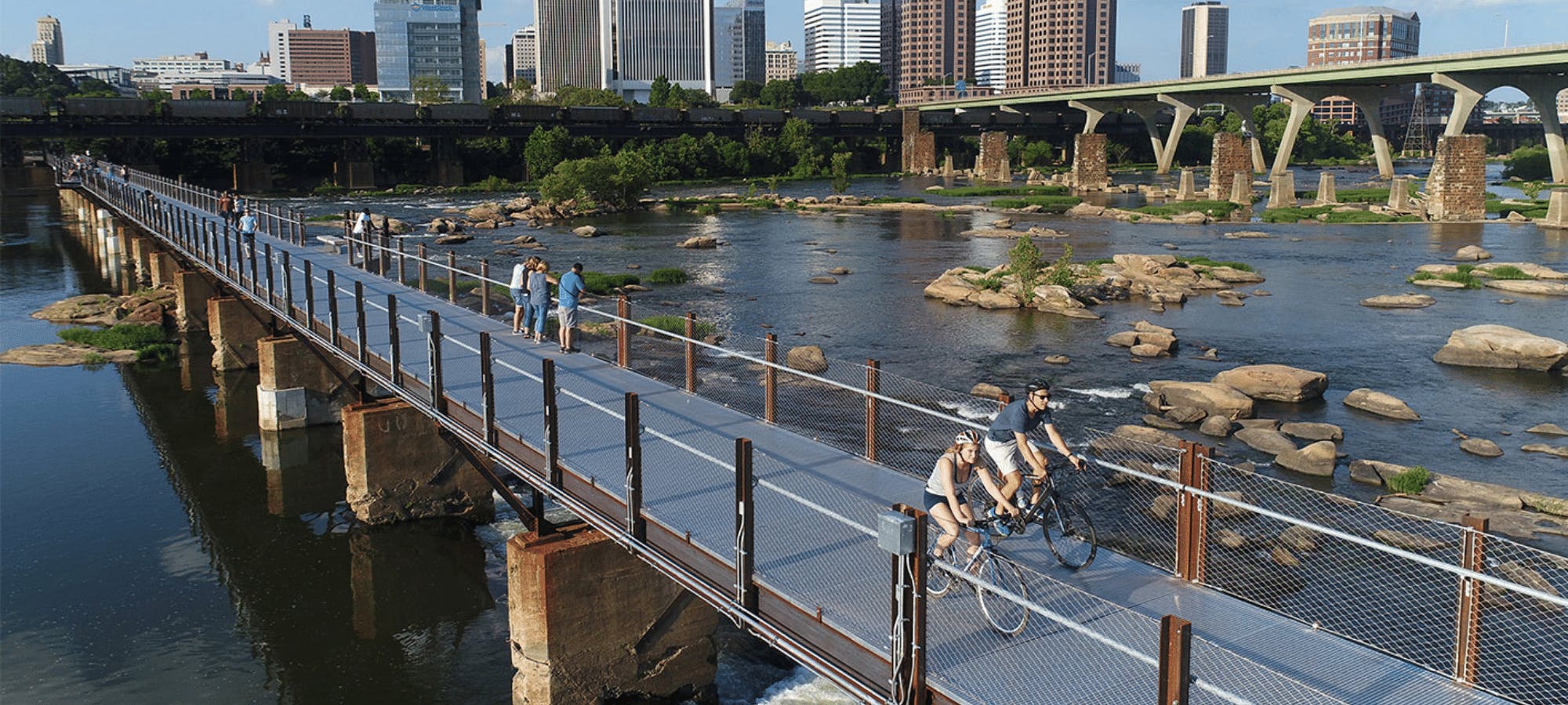
T. Tyler Potterfield Memorial Bridge
This 1,600-foot-long pedestrian and cycling pathway sits atop a former hydroelectric dam, some 20 feet above the river, connecting the north bank on Brown’s Island to the south bank of Manchester. Completed in 2016, and named for the late City of Richmond senior planner T. Tyler Potterfield, the bridge provides unequaled river vistas. The panoramic views of the downtown skyline paired with sounds that fail to give the impression of the extraordinarily close relationship of the bridge to the roaring river, are an experience we highly recommend. The wheelchair accessible bridge is open to pedestrians and cyclists 24 hours a day. Access is provided from either side of the river: Brown’s Island on the north and from Semmes Ave. on the south side.
Unique views of the James River, the city skyline and historic sites can be seen from atop the Floodwall on the southern side. Completed in 1995 to protect areas of downtown and Manchester from devastating flooding, the southbank section comprises Floodwall Park, also known as Diversity Park, a popular spot for hikers, runners, fishermen, bird watchers and kayakers.
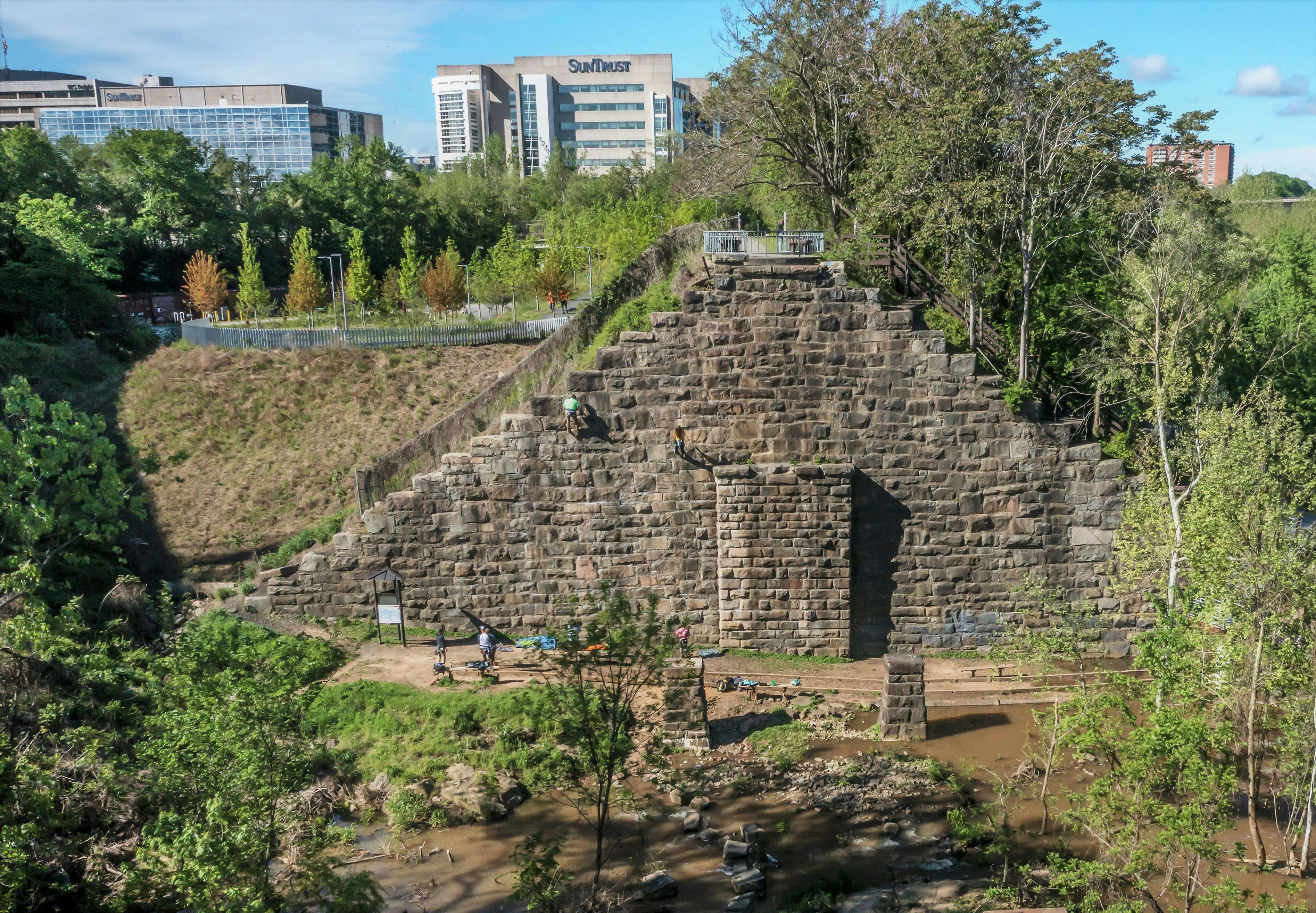
This area, under the Manchester Bridge, is a unique outdoor climbing venue under a series of abandoned train trestles that have been equipped with bolts and shutts. Here, climbers can hone their skills of leading, both trad and sport, rappelling and self-rescue. Climbers and non-climbers alike will enjoy a visit to this uncommon section of the James River Park System.
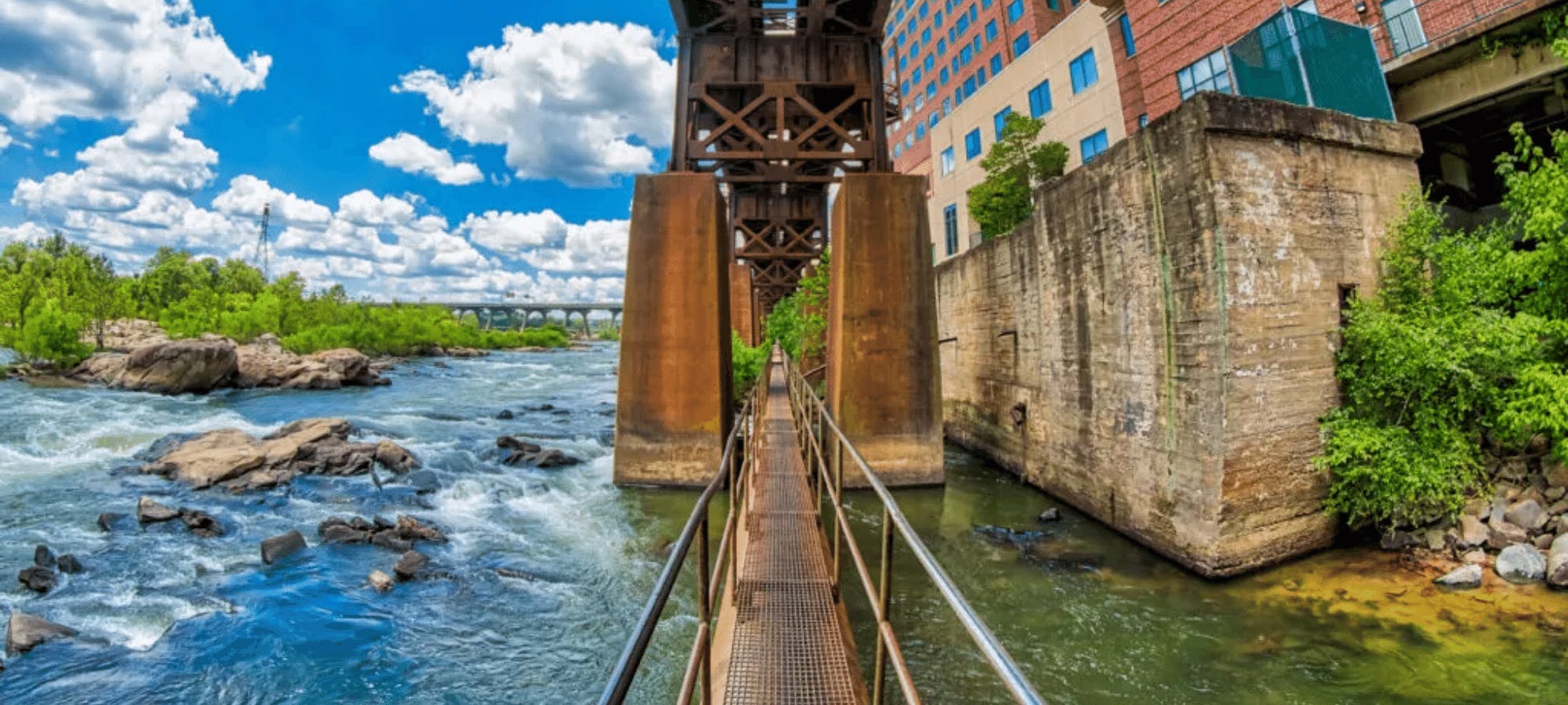
James River Pipeline
The Pipeline Rapids walkway may be downtown Richmond’s best kept secret. A wonderful place to watch nature and escape the city for even just a few minutes, the Pipeline is also a favorite for those looking for a moderate level of thrill as it brings you face-to-face with the full rage of the river's rapids. From the parking lot at the end of S. 12th Street, you walk to a metal ladder, then descend to the metal catwalk atop the pipeline, which offers up close and personal views of the Pipeline Rapids. Please pay attention to water levels for safety’s sake, and keep an eye on the CSX railway viaduct overhead.
James River Trails in Downtown Richmond
Riverfront Hiking and Biking Trails (length, type of surface, rating)
- Canal Walk (1.25 miles, paved, rated easy)
- Virginia Capital Trail (52 miles, paved, rated easy to moderate)
- Belle Isle Trail (3 miles, gravel, rated easy to moderate)
- Richmond Slave Trail (2.5 miles, mixed surface, rated easy)
- Ancarrow´s East Trail (2.5 miles, mixed surface, rated easy)
- Floodwall Walk (.5 miles, paved, rated easy)
- North Bank Trail (2.5 miles, dirt*, rated difficult)
- Buttermilk Trail (2.5 miles, dirt*, rated difficult)
If chilling isn’t what you’re about, North Bank Trail provides an excellent challenge for hikers and mountain bikers. This advanced trail runs uninterrupted from Pumphouse Park to the Tredegar Parking lot and offers panoramic views of the river unavailable in other sections of the Park. Technical and fast flowing, this singletrack is rocky and rugged in spots with some steep climbs and fast descents. The trail can be elongated by crossing the Boulevard (Nickel) Bridge and hooking up with the Buttermilk, Forest Hill and Belle Isle Trails creating a mega loop.
Buttermilk trail was aptly named because when milk was still delivered to people’s homes, the milkman would store the buttermilk in a cool well that is still located on the side of the trail. The trail parallels the south side of the river and is a real challenge and considered the most difficult of the different sections of the James River Park System. Buttermilk combines tight, twisty, fast descents and steep climbs with lots of rocks and roots. Several creek crossings and some bridges and rock gardens add character to one of the most beloved trail systems in the Richmond area.
James River Park System Hours
The park opens at sunrise and closes at sunset, unless otherwise noted by official posted park system signage.
Downtown Richmond Parking and Transportation
Free Riverfront Parking:
- On-street parking on S. 2nd Street between Brown’s Island Way and E. Byrd Street (limited daytime parking)
- On-street parking on S. 5th Street on the west side of the street from Tredegar to E. Byrd Street (very limited daytime parking)
- The Belle Isle parking lot is located at the corner of Tredegar Street and Brown’s Island Way (limited daytime parking)
Paid Public Riverfront Parking:
- American Civil War Museum parking lot, 480 Tredegar Street, Limited hours during special events
- Delta Hotels by Marriott parking deck, 555 E. Canal Street, Public parking 24/7
- 5th & Canal Street, Public parking 24/7, Pay through “ParkMobile” by app or QR code, see signage on-site
- 4th & Canal Street, Public parking 24/7, Pay through “ParkMobile” by app or QR code, see signage on-site
- 1200 E Byrd Street (Reynolds lot), Public parking 24/7, See signage and pay-to-park kiosk on-site
- 8th & Cary Parking Deck, Public parking 24/7, See signage and pay-to-park kiosk on-site
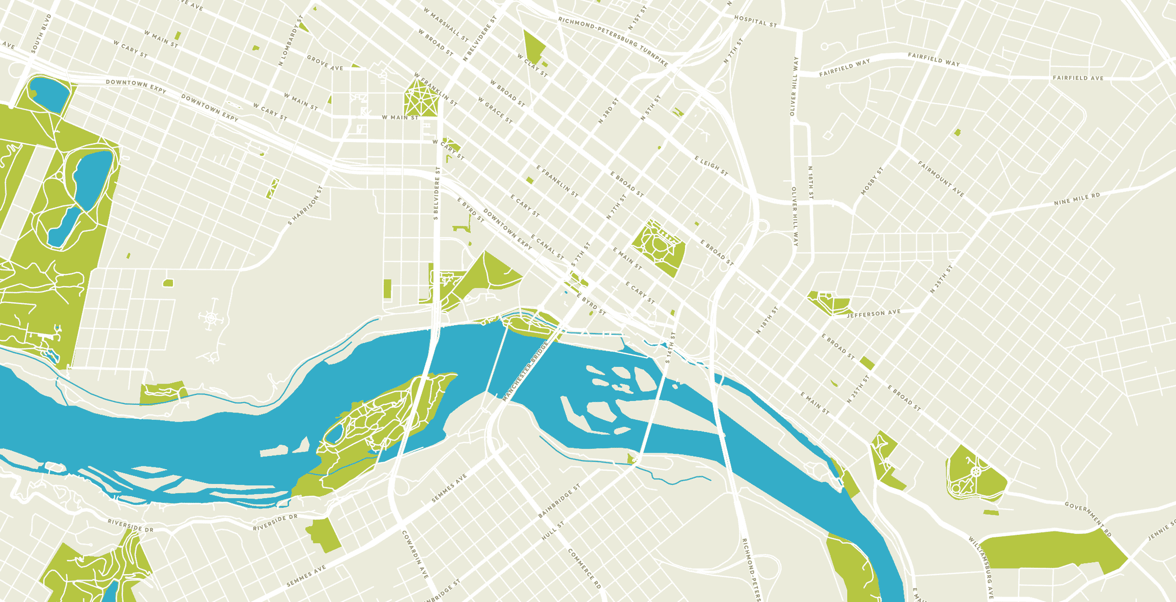
- See MAP for additional options
Riverfront Bike Parking/Riding:
- Bike racks are located along Tredegar Street, and at the vehicular bridge on the western end of Brown’s Island nearest historic Tredegar.
- Bike Share stations are located at the Turning Basin and at 620 Tredegar Street. Explore all of the RVA Bike Share stations here.
- Bike racks are located along Low Line Green, the Turning Basin, next to Casa Del Barco, on Tredegar Street between 5th and 7th Streets and at the vehicular bridge on the western end of Brown’s Island (nearest historic Tredegar).
Riverfront Bus Transportation:
Getting to Richmond's riverfront is easy when you ride GRTC. Just take the route #87 bus across the Lee Bridge to the stops at 2nd Street and Brown's Island Way near Tredegar or at 2nd and Spring Street. The route #87 bus runs every 60 minutes. On its way back across the river, the bus stops at 2nd and Spring Street and again at 2nd Street closer to the Virginia War Memorial. Just look for the purple GRTC signs, or track your bus via the free Transit App!
Find more information about Parking and Transportation in Downtown Richmond here.

Downtown Richmond has tons of outdoor activities to offer. Find out what else to explore in the city!